
Navigating the Map
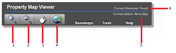
Map Banner - Navigation Tools |
|
 |
|
| 1 - Zoom In: Hold left button and drag mouse to draw rectangle. Release button to zoom in to defined area. | |
| 2 - Zoom Out: Hold left button and drag mouse to draw rectangle. Release button to zoom out from defined area. | |
| 3 - Move Map: Hold left button and drag mouse to move the map | |
| 4 - Zoom to Full Extent: Click to zoom map to default level and position | |
| 5 - Active Tool: Displays currently active tool | |
| 6 - Active Basemap: Displays visible basemap |
Zoom Slider |
|
 |
|
| 1 - Zoom In: Click to zoom in one scale level |
|
| 2 - Zoom Out: Click to zoom out one scale level |
|
| 3 - Current Zoom Level: Shows current zoom level. Click and hold mouse button to drag to zoom level. |
Back to top
Switching Basemaps
Map Banner - Basemaps Menu |
|
 |
|
| 1 - Switch Basemap: Hover over menu to view available basemaps. Click menu item to switch. |
Back to top
Using the Table of Contents
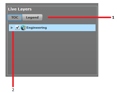
Table of Contents |
|
 |
|
| 1 - Activate Table of Contents: Click TOC button to view Table of Contents | |
| 2 - Expand layers: Click to left of map service or grouped layer to expand list of layers | |
 |
|
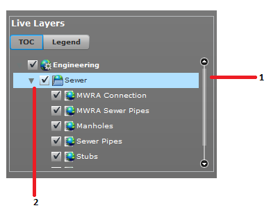
| 1 - Scroll Table of Contents: Use scroll bar to see full list of layers | |
| 2 - Toggle layers on and off: Use check marks to turn on individual layers or groups of layers. |
Back to top
Viewing the Legend
Legend |
|
 |
|
| 1 - Activate Legend: Click Legend button to view legend | |
| 2 - Select Map Service: Each map service has its own image to display layer symbology. Click tab of corresponding map service to view its legend. | |
| 3 - Scroll Legend: Use the scroll bar to see full list of layer symbology |
Back to top
Using Search Tools
Select Search Tool |
|
 |
|
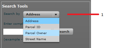
| 1 - Select Search Tool: Click drop down to select search tool. | |
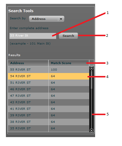
Search by Address
 |
|
| 1 - Enter address: Enter address to search | |
| 2 - Search Button: Execute search. | |
| 3 - Match Scores: Each record returned is given a match score from 0 to 100. An exact match is a score of 100. | |
| 4 - Highlighted result on map: All results are shown on the map. Hover over a record in the grid to highlight the feature on the map | |
| 5 - Scroll results: Use the scroll bar to view the full list of results. | |
Search by Parcel ID
 |
|
| 1 - Enter address: Enter parcel ID string. Map, Block and Lot values are seperated by '-' | |
| 2 - Search Button: Execute search. | |
| 3 - Sort Data: Click column header to sort results. | |
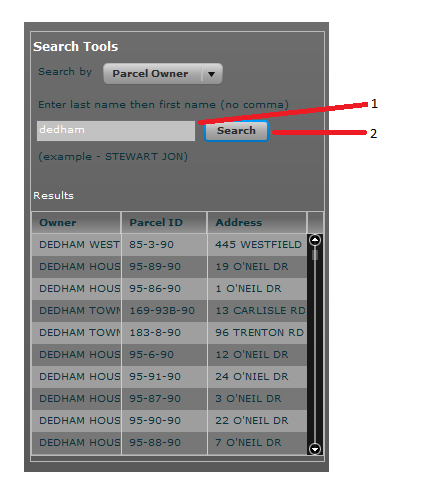
Search by Parcel Owner
 |
|
| 1 - Enter owner name: Type owner's last name followed by first name seperated by a space. Type a portion of a name for a broader search. | |
| 2 - Search Button: Execute search. | |
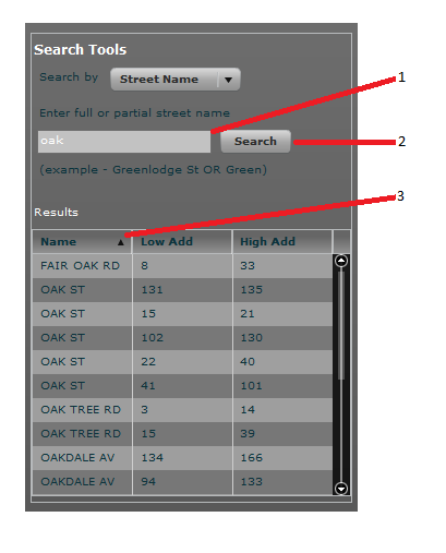
Search by Street Name
 |
|
| 1 - Enter street: Enter full or partial street name. | |
| 2 - Search Button: Execute search. | |
| 3 - Review Results: A record is returned for each street segment that meets the search criteria. |
Back to top
Using Tool Widgets
Map Banner - Tools Menu |
|
 |
|
| 1 - Open tool widget: Hover over menu to view available tools. Click tool menu item to open window. | |
Tool Widget Window |
|
 |
|
| 1 - Exit Button: Closes the widget window | |
| 2 - Minimize Button : Shrinks and moves widget window | |
| 3 - Tool controls: Each tool has its own set of tools for interacting with the map. | |
Tool Widget Manager |
|
 |
|
| 1 - Scroll up: Scrolls up through open widgets. Activates only if all opened widgets do not fit on screen. | |
| 2 - Scroll down: Scrolls down through open widget. Activates only if all opened widgets do not fit on screen. |
Back to top
Parcel Identify Tool
Parcel Identification Tool |
|
 |
|
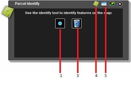
| 1 - Activate Identify Tool: Click tool button to activate Parcel Identification Tool. | |
| 2 - Click map: Click the map to get parcel information. | |
| 3 - Clear results: Click the trash button to clear results. | |
| 4 - Toggle to tool: Switches window from results to tool activation window. | |
| 5 - Toggle to results: Switches window from tool activation to results window. | |
Results Window |
|
 |
|
| 1 - Results Window: View Assessor information for each selected parcel. | |
| 2 - Get Property Card Info: Click the link button to see property card for parcel. | |
| 3 - Scroll through results: Use scroll bar to see more results. |
Back to top
Parcel Abutter Tool
Parcel Abutter Tool |
|
 |
|
| 1 - Activate Abutter Tool: Click tool button to activate Parcel Abutter Tool. | |
| 2 - Select buffer distance: Select distance to buffer parcel feature(s). | |
| 3 - Click map: Click the map to select parcel feature(s) to buffer. | |
| 4 - Clear results: Click the trash button to clear results. | |
Map Results |
|
 |
|
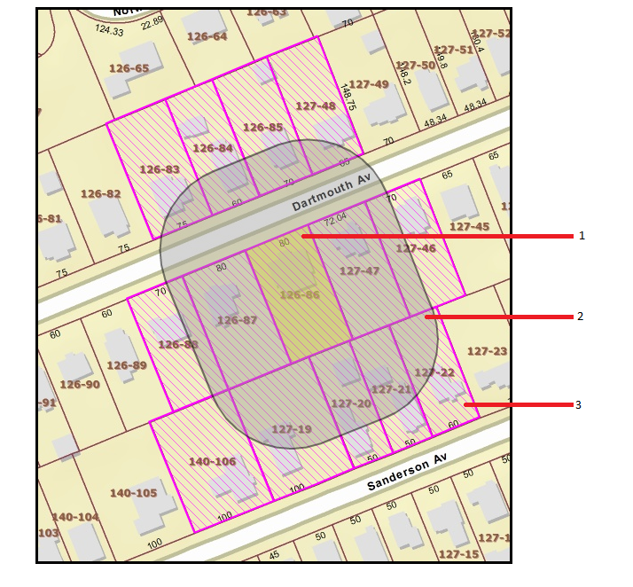
| 1 - Selected Parcel(s): Parcel(s) selected with tool are highlighted in yellow. | |
| 2 - Buffer: Parcel buffer is shaded gray. | |
| 3 - Intersecting Parcels: Parcels intersecting buffer are marked with purple lines. | |
Abutter Results |
|
 |
|
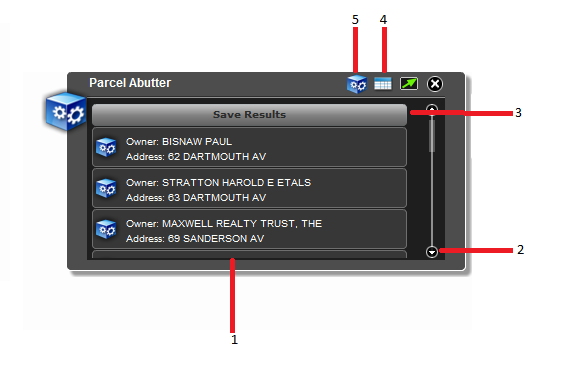
| 1 - Results Window: View parcel records from buffer results. | |
| 2 - Scroll through results: Use scroll bar to see more results. | |
| 3 - Export: Use the button to export results to a text file. The file can be imported into Microsoft Word to create a mailing list. | |
| 4 - Toggle to results: Switches window from tool activation to results window. | |
| 5 - Toggle to tool: Switches window from results to tool activation window. |
Back to top
Printing the map
Map Banner - Tools Menu |
|
|
|
| 1 - Open print window: Hover over menu to view available tools. Click Print menu item. | |
Print Window |
|
 |
|
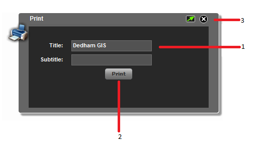
| 1 - Title & Subtitle: Enter Title and subtitle for printed map | |
| 2 - Print button: Prints the map. | |
| 3 - Exit button: Closes the print window. |
Back to top
Drawing Tools
Drawing Tools |
|
 |
|
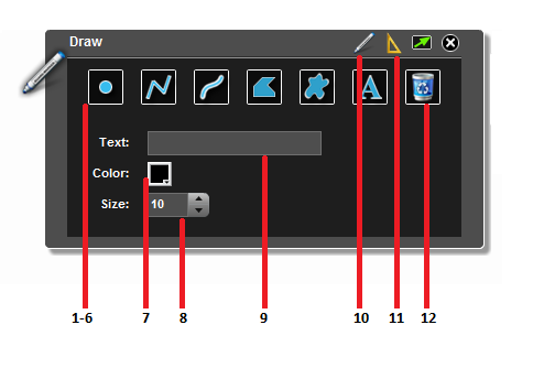
| 1 thru 6 - Drawing Tools: Select type of graphic to draw. Point, line, free form line, polygon, free form polygon or text. | |
| 7 - Color: Select draw color. | |
| 8 - Size: Pick font size or line thickness. | |
| 9 - Text: Enter text to draw with text drawing tool. | |
| 10 - Toggle to tools:Switches window from measurement units to tools window | |
| 11 - Toggle to measurements: Switches window from tools to measurement units window | |
| 12 - Erase: Clears all graphics from map. | |
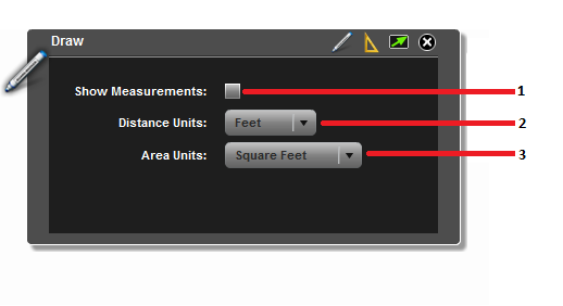
Measurement Unit Options |
|
 |
|
| 1 - Enable Measurements: Check box to see measurments when drawing graphics. Point graphics show map coordinates in MA State Plane, feet. | |
| 2 - Distance Units: Select feet, meters or miles. | |
| 3 - Area Units: Select square feet, square meters, square miles or acres. |
Back to top
Making Measurements
| Training video - How to measure a distance |
Back to top